Everything You Need to Know Before Hiking Nam Xay Viewpoint (2026)

We spent days waiting for the mud to dry to bring you this 2026 guide. Nam Xay Viewpoint is more than just an Instagram photo; it’s a humid, steep scramble that rewards you with the best 360-degree views in Laos.
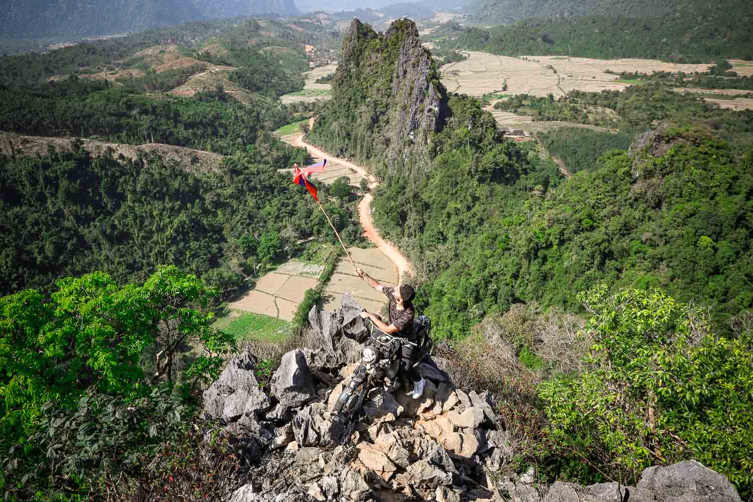
You’ve seen the photo. The one with the motorbike perched on a jagged limestone peak, the Lao flag snapping in the wind. Well, we got up there, and it was one of those iconic photos we want in our travel diary. To be fair, behind that pretty photo you can see down below, there is sweat and tears.
Yep, it’s what you’ll conveniently see on Instagram reels. It’s humid, rugged, steep, and crumbled. Even though it’s one of the most rewarding hikes in Southeast Asia, we sign up for it.
When we hiked Nam Xay, it wasn’t just a “steep scramble”—it was a 30-minute battle against mud and gravity that left us questioning our life choices halfway up.
But standing at the top, clinging to that rusted bike with the valley sprawling out below us, it became the single most memorable moment of our Southeast Asia backpacking trip. Yes, it is one of the most fun experiences in Vang Vieng, but please don’t underestimate it.
This isn’t just a guide to the entry fees and opening times; this is the reality check I wish I had read before I tried to climb those sharp rocks in the wrong shoes.

Key Highlights
- Is Nam Xay Viewpoint Worth the Effort? (Our honest take)
- 2026 Logistics: Entrance Fees & Opening Hours
- How to Get There: Namsong Bridge & Road Conditions
- The Hike: Difficulty, Terrain & Time
- The Summit: The Motorbike & The View
- Safety & Gear: What to Wear (and what not to!)
- Travel Insurance: Why SafetyWing is our choice
This post includes affiliate links. We may earn a small commission at no cost to you. You can also buy us a coffee to support the site directly. Learn more in our Cookie Policy.

👋Toti & Ale here
London couple, 45+ countries, 300+ guides. We are full-time content creators, travelling as slowmads, spending quality time in places we love the most. We run this and several other blogs from the best places in the world. This guide is based on direct experience on the trails of Vang Vieng. Site visits included time spent at Nam Xay to ensure accurate, first-hand reporting.
January 25, 2026 Update: Key changes include the new 20,000 LAK entrance fee, the addition of a second summit motorbike to manage crowds, the Namsong Bridge now toll-free for scooters, and improved dirt-road conditions during the 2026 dry season. This guide is based solely on our direct, road-tested experience—no AI involved.
Was the viewpoint worth the effort?
Yes, totally. We loved the view from the top of Nam Xay viewpoint. Still to date is one of the best hikes, yet also figuring into the list of the hardest ones. It wasn’t easy from the beginning. We spent a few days in Vang Vieng, waiting for the weather to clear out and getting ready for a new adventure.
The Hike to the top is for moderately fit hikers. You will walk through thick jungle, steep, uneven terrain, eventually steps, and passing under tree branches.
Apart from that, the viewpoint is fantastic. We were rewarded with the best view of Laos countryside. Even though we know what to expect, the motorbike ancored on the edge astonished us. We both waved the Laos national flag so fast, because of the achived hard hike. The landscape, almost looks like Ninh Binh one in Vietnam. Actually, this hike can compare to Hang Mua Caves Hike (even though this is tougher).
How to get to Nam Xay Viewpoint?
Nam Xay viewpoint isn’t far from Vang Vieng centre, and you can either join a local tour, or rent a motorbike to go on your own.
Backpackers usually choose the second, and because of the budget, we did it, too. It is easy to rent a motorbike in Vang Vieng, but be aware of scams. (We rented here, and everything went smoothly.)
Renting a bike cost us 100K Kip per day ($4.5 | €4.2 | £3.5), and we filled the tank with 50K Kip, which lasted for about two days, roaming around every landmark of Vang Vieng.
To get to Nam Xay Viewpoint you must get out of Vang Vieng Town through Namsong Bridge. This wobbling scary bridge is the only way to get in and out.
Alessia had to walk on the bridge, because I wasn’t feeling safe to drive in two on a motorbike. The view is beautiful, though. Officially, the bridge is closed, and you don’t have to pay the crossing fee anymore.
The road from Vang Vieng to Nam Xai viewpoint is scenic, passing through villages and small bridges over rivers. However, there is no asphalt, and you must be comfortable on dirt roads.
Your clothes on the way to the viewpoint will get very dirty, as will the red terrain. Take Sunglasses with you to cover your eyes.

Take a tour to Nam Xay Viewpoint
If you aren’t willing to drive through these dirt roads, we get that. It was hard to learn for me, too. Well, you don’t have to give up; you can join a group tour.
This tour will pick you up at the hotel/hostel, and drive through Vang Vieng countryside. The tour includes not only Nam Xay hike but also the Blue Lagoon and Phu Kham Cave Vang Vieng, two other interesting sights. CHECK THE AVAILABILITY.
Other ways to get to Nam Xay besides renting a bike
Renting a bike is a hassle, and sometimes, travel insurance doesn’t cover it if something happens. (Read our review on Safetywing to understand why we are always insured with them).
You can still reach the hike and enjoy the day out by renting a motorbike (the best scenic way with a stop in the villages) or negotiating with a Tuk-tuk driver. Usually, they will ask for 250K Kip for a full day ($11 | €10.5 | £9).
Vang Vieng Buggy Rentals: The 2026 Upgrade
If you aren’t comfortable on a scooter, renting a buggy car is the ultimate way to reach Nam Xay.
- Costs: Very expensive, expect to pay around $80 (approx. 1,700,000 LAK) for a Full-day rentals.
- Why choose a Buggy? The road to Nam Xay is famous for deep dust in the dry season and “motorbike-eating” mud in the rainy season. Buggies handle potholes much better and let you bring a passenger in relative comfort.
- Pro Tip: Most rentals include a “safety briefing.” Even in a buggy, wear your sunglasses—the dust kicked up by other vehicles is no joke!
Namxay Viewpoint, Blue Lagoon 1 & Phoukham Cave Guided tour
Price: £20 (€23 | $24) per person.
Rating: 4.6 🌟 (125 Reviews)
Duration: 3.5 Hours
Includes: All entrance fees + Guide.
FREE CANCELLATION
Vang Vieng Hike – Nam Xay Viewpoint
Nam Xay entrance fee and opening hours
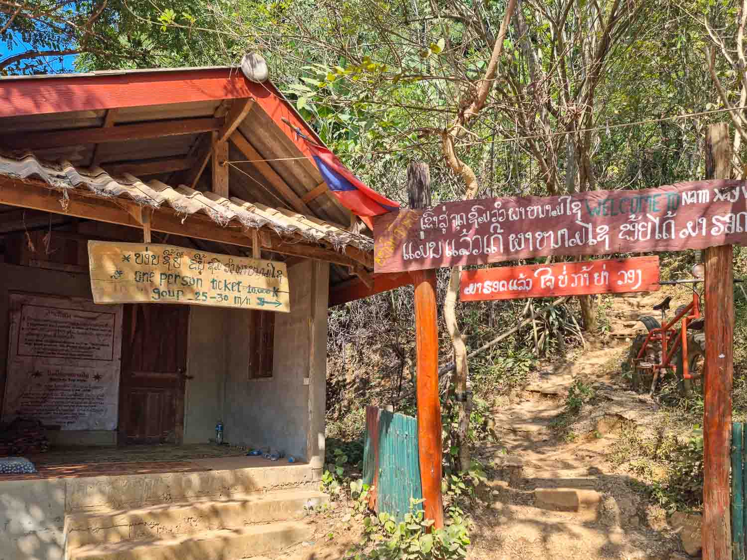
Nam Xay entrance fee costs less than 1 USD; only 10K Kip ($0.5 | €0.40 | 0.35) per person. There is a Ticket Office right before the entrance, and it is necessary. The personnel will count the number of people that hike every day, and by the end, they need to keep track if somebody is still up there.
After dark, there are no lights. The best hike in Vang Vieng opens every day from 9 am to 5.30 pm. Even though sunset is awesome from above, it can get pretty hard to see barely anything on the way down.
There is a wide parking lot if you are coming by bike. We had no problem leaving our helmets on, as it is pretty safe.

The Hardest Hike in Vang Vieng – Our Experience
This was one of the hardest hikes we have ever done, but the true reason is that we were not fit for the purpose. We were just one month into our first epic Southeast Asia trip, and so adjusting to temperature, food and strength.
The hike is less of a trail and more of a limestone scramble. It takes about 30 to 45 minutes to get to the top. We doubled that time, I guess. It was slippery, with uneven steps and a climbing part.
You’ll find yourself pulling your weight up using bamboo handrails and thick tree roots. The jagged limestone rocks are sharp enough that you’ll want to keep your hands free for balance.
About halfway up, look out for the bamboo rest huts—they are a lifesaver for catching your breath. Once you reach the summit, the reward is more than just the view; there are seats in the shade, and users in current reviews report a hammock (while we didn’t find one, let us know in the comments).
Cool down before queuing for the photo spot on the motorbike.
However, even if it was hard for us, it is still one of the most memorable and a story to tell every time we talk about Laos. Avoid it if it is raining, or has been for a couple of days before.

How to prepare for the hike
As said before, if you are fit, you will have no problems but don’t undervalue this hike. To be honest, it wasn’t the way up that was the hardest, but the way down. My knees are still hurting just writing about that and remembering the pain.
We had a few people doing it with sandals and flip-flops, and it wasn’t comfortable. It’s better if you wear sneakers, not necessarily hiking shoes.
Also, consider wearing breathable shirts and shorts. You will walk through a thick jungle, and it gets very humid. However, keep a change of outfit for the top if you are up for a proper Instagram photo from Laos.
There are a couple of stores at the entrance of Nam Xay viewpoint. If you haven’t got enough water, get some big bottles. You will need them.

The best time to go for the hike
When planning this hike, you must consider the weather overall—not just on the day you are planning to go but also if it has rained the days before. It takes a couple of days to dry out, so bear this in mind.
The best time to visit Vang Vieng and so do the hike, is from November to January, during Laos dry season. We visited Vang Vieng in December, and the weather was fantastic, with one day of rain overall. During the dry season, it gets very hot during the day, so plan the hike early in the morning or late in the afternoon.
Timing Your Hike: Sunset vs. Sunrise
- Sunrise (6:00 AM – 7:30 AM): The best time for peace. You’ll often see mist rolling through the limestone peaks, and the temperature is much cooler. It’s the only time you won’t have to queue for a photo with the motorbike.
- Sunset (4:30 PM – 5:45 PM): The “Golden Hour.” This is when the valley turns a deep orange. It is busier and much hotter, but the colors are unbeatable for photography.
- The 2026 Warning: Do not stay at the top until it is pitch black. The descent is dangerous without light. Aim to start heading down at least 15 minutes before the sun fully disappears.
Nam Xay vs. Pha Ngern vs. Silver Cliff: Which Viewpoint is for You?
Vang Vieng is famous for its karst hikes, each offering a unique experience. Here’s how they compare in 2026:
- Nam Xay Viewpoint: The “All-Rounder.” This is the most recognized viewpoint, famous for its iconic motorbike and offering dramatic 360-degree views of the valley. The ascent is a 30-40 minute vertical scramble.
- Pha Ngern Viewpoint: The “Challenge.” Also known as Silver Cliff (not to be confused with the separate Silver Cliff Viewpoint), this viewpoint is significantly higher than Nam Xay. There are two levels: the first takes 45 minutes, and the second takes another 20. It offers the best view of the Nam Song River but requires more stamina.
- Silver Cliff Viewpoint (Pha Hon Kham): The “Quiet Alternative.” Sometimes mistakenly called Pha Ngern, Silver Cliff Viewpoint (Pha Hon Kham) is a distinct trail located nearby. It’s moderately easier and much less crowded, but lacks props like the motorbike or flags.
- Phapoungkham (Airplane/Pegasus): The “New Rival.” If you want an airplane or a Pegasus statue instead of a motorbike, this is a shorter, easier 20-minute hike nearby.
Laos Travel insurance Tips
Don’t skip this part. After four years of full-time travel across Southeast Asia, we’ve learned that travel insurance isn’t just a “nice to have”—it’s your only safety net. In Vang Vieng, where hospital facilities are extremely limited, a serious accident often requires an expensive medical evacuation to Thailand.
Why we use SafetyWing travelling through Laos
We use SafetyWing Nomad Insurance because it’s built for travellers like us. It’s a subscription-style plan that we can start or stop anytime, even if we’re already on the road. Get a quote here.
Crucial Tips for Nam Xay & Vang Vieng:
- Motorbike Coverage: SafetyWing covers motorbike and scooter accidents (up to $250,000), but only if you are properly licensed in your home country, wearing a helmet, and completely sober.
- Hiking & Adventure: Nam Xay is considered a “leisure” hike (under 4,500m), so it is covered under the standard Nomad Insurance Essential plan. No extra “Adventure Sports” add-on is required for this specific climb.
- Medical Evacuation: This is the most important feature. If you get hurt on the Nam Xay trail, SafetyWing covers up to $100,000 for emergency evacuation to a better-equipped hospital.
Bills from private hospitals in the region can easily top $20,000 for a single surgery. We pay about $56 per month for peace of mind—a small price to pay to ensure a slip on a muddy trail doesn’t end our travels (and our bank account) forever. The alternative to Safetywing is Heymondo. Read our fair comparison.
Hey Mondo is our partner and we use for short trips, up to 60 days at time. For our readers they offer a great 5% discount.

Things to do around Nam Xay Viewpoint
If you are leaving Vang Vieng for an adventure, you must plan it well and include a few other activities besides Nam Xay.
The hiking viewpoint is in the centre of other spots worth visiting in Vang Vieng, the Blue Lagoon, the Caves, and some villages.
READ ALL OUR GUIDES ABOUT LAOS

LAOS ITINERARY 2 WEEKS

IS LAOS WORTH VISITING?

BEST TIME TO VISIT LAOS
MEKONG RIVER SLOW BOAT
BEST HOSTELS IN VANG VIENG

IS VANG VIENG WORTH VISITING?

FROM VANG VIENG TO VIENTIANE